


5. Lamborghini Gallardo EPS – Italia

6. Ferrari 612 Scaglietti – Italia


 THE RESURRECTION
 THE ASCENSION


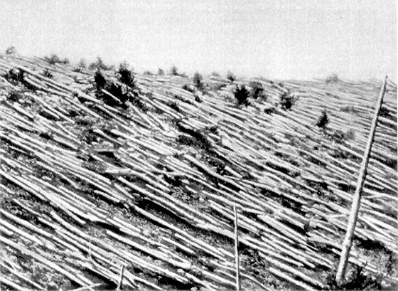
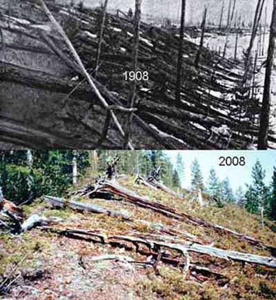
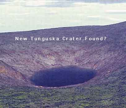
![[Jun30_Tunguska.gif]](https://blogger.googleusercontent.com/img/b/R29vZ2xl/AVvXsEg34TG8NHZf9lU99i1VCZZMdGEXBK4tqFEBeKXJj5qH6rFOpAA8QXv-y5n_ndZcHlLccKYDpHY3G150WvOfzjw9K-FheaNf_9fi5jRUWD8YptCJubtxY8wdjIcX_dr8cRUcWQzDi8j3QLI/s1600/Jun30_Tunguska.gif)


The strange and weirdly beautiful terraced pools of Pamukkale have been appreciated for over two millennia and yet still remain a little known wonder of the world. Thousands of years ago earthquakes, which are common in Turkey, created fractures that allowed powerful hot springs to bring water rich in calcium carbonate to the surface. As the water evaporated the chalky material condensed and formed layer-upon-layer of Travertine and thus slowly built up the walls over time in the same way that a stalactite forms in a cave. Apparently Pammakale means Castle of Cotton but the Greco-Romans built a town above it called Heirapolis – meaning “Holy City” or “Sacred City”. They too recognised it as a rare and important place attributing healing powers to the milky-white waters.


These large, spherical, alien and strangely beautiful boulders are mainly located on Koekohe Beach, part of the Otago coast of New Zealand’s South Island. Known as “Moeraki Boulders” they were originally formed on the sea floor from sedimentary deposits that accreted around a core in the same way that a pearl will form around a particle of sand. The erosion of the cliffs often reveals these boulders from the surrounding mudstone allowing them to join those already on the beach. Some of the larger boulders weigh several tonnes and can be up to three metres wide.
Maori legend attributes their origin to the arrival of the first ancestors / giants who came in the great Araiteuru canoe which was sunk by three great waves at nearby Matakaea.

It is said by the Maoris that some of the surviving crew of the Araiteuru canoe were turned into stone and became mountains. The Moeraki boulders are said to be the pots and chattels from the canoe.


At the summit of Mount Teide, one of the largest Island volcanoes in the World is the Las Cañadas caldera. The crater, which is an enourmous sixteen kilometres across, is a picture of what Hell might look like if it cooled a little. Shear walls that formed when the caldera first collapsed encircle this dry and alien place. And, with an arrogance than can only be accepted as typical, humanity has built roads and observatories across this no mans land that is little more than a plug over a sleeping yet still active and very large volcano. When we visited it some years ago we were standing in the viewing gallery when the ground beneath our feet trembled and several windows suddenly cracked. The sleeping giant was grumbling in its sleep. The land mass created by the volcano is Tenerife in the Canary Islands.

Found on both land and in the ocean throughout the Bahamas and the national waters of Belize are deep circular cavities known as Blue Holes which are often the entrances to cave networks, some of them up to 14 kilometres in length. Divers have reported a vast number of aquatic creatures some of which are still new to science. In addition, they’ve recorded chambers filled with stalactites and stalagmites which only form in dry caves. For the explorers this was proof that at one time, nearly 65,000 years ago, when the world was in the grip of the last major ice age, the sea level of the Bahamas was up to 150 metres lower than it is today. Over time the limestone of the islands was eroded by water and vast cave networks created. When sea levels rose again about 10,000 years ago some of these collapsed inwards and the Blue Holes were formed


Currently scientists believe that they know what caused this formation. Hey! It's a Ri chat structure ... whatever that really means. A more Bizarre theory is that it is the impact site of an ancient but very powerful bomb.
From space this mysterious depression in the Sahara Desert of Mauritania really does look like a human eye. The image to the left is the "pupil" but a visit to Google Earth zoomed out a little will reveal the cliffs that make up the rest of the eye. This natural phenomenon is actually a richat structure caused by the dome shaped symmetrical uplifting of underlying geology now made visible by millennia of erosion. Please note that this explanation is not wholly accepted by the scientific community. There still remain academics that believe it is the sight of a meteor impact and yet others still that believe it resembles the formations caused by underground nuclear blasts. By the way, we estimate that the detonation would have had to be in the gigaton range. Currently no country in the world has a weapon even close to this destructive yield.

 Researchers at the space agency believe they have discovered vital clues that appeared to indicate that primitive aliens could be living on the planet. Data from Nasa's Cassini probe has analysed the complex chemistry on the surface of Titan, which experts say is the only moon around the planet to have a dense atmosphere.
 the moon is generally too cold to support even liquid water on its surface. The research has been detailed in two separate studies. The first paper, in the journal Icarus, shows that hydrogen gas flowing throughout the planet’s atmosphere disappeared at the surface. This suggested that alien forms could in fact breathe. The second paper, in the Journal of Geophysical Research, concluded that there was lack of the chemical on the surface. Scientists were then led to believe it had been possibly consumed by life. Researchers had expected sunlight interacting with chemicals in the atmosphere to produce acetylene gas. But the Cassini probe did not detect any such gas. Chris McKay, an astrobiologist at Nasa Ames Research Centre, at Moffett Field,
  California who led the research, said: “We suggested hydrogen consumption because it's the obvious gas for life to consume on Titan, similar to the way we consume oxygen on Earth. "If these signs do turn out to be a sign of life, it would be doubly exciting because it would represent a second form of life independent from water-based life on Earth.” Professor John Zarnecki, of the Open University, added: “We believe the chemistry is there for life to form. It just needs heat and warmth to kick-start the process. “In four billion years’ time, when the Sun swells into a red giant, it could be paradise on Titan.” They warned, however, that there could be other explanations for the findings. But taken together, they two indicate two important conditions necessary for methane-based life to exist.


![[image]](http://www.archaeology.org/0005/abstracts/thumbnails/nasca.gif)
Ever since the first commercial trans-Andean aviators spotted them in the 1930s, the giant ground drawings that cover 400 square miles of southern Peru's desert coast have remained an enigma. Acre-sized tracings of hummingbirds, foxes, and condors; a 100-foot-tall man with owllike eyes, his raised arms beckoning to us from a hillside; dozens of spirals, zigzags, triangles, and trapezoids; and 1,000 miles of long, straight lines crisscross a dry wasteland that bears an uncanny resemblance to the surface of Mars. Could these geoglyphs be effigies of ancient animal gods or patterns of constellations? Are they roads, star pointers, maybe even a gigantic map? If the people who lived here 2,000 years ago had only a simple technology, how did they manage to construct such precise figures? Did they have a plan? If so, who ordained it? It all seems so otherworldly. To comprehend the Nasca lines, created by the removal of desert rock to reveal the pale pink sand beneath, visitors have proposed every imaginable explanation--from runways for spaceships to tracks for Olympic athletes, from op art to pop art, to astronomical observatories. As much as the lines awe me, I marvel equally at the imagination of the people who have sought explanations for them.
Water, walking, astronomy, kinship, division of labor and ceremonial responsibility, cleansing and sweeping, radiality: there is a place for all of these human actions and concepts in a complex, but nonetheless believable story of the Nasca lines. Above all, I think the lines were made to walk upon; they were pathways. I have no doubt that some sort of ritual on the ray centers and trapezoids, wherein people assembled for reasons connected to the ritual acquisition of water, was involved. The patterns of lines also speak of relations among people who maintained them, and possibly of astronomy via the connection between sunrise/sunset positions and the date of arrival of water in the valleys adjacent to the pampa. Whatever the mosaic of explanations, our cardinal rule has been that everything must make sense in the context of what we know about Andean culture in general and about Nasca culture in particular. We can no longer view the Nasca lines as the product of a massive superhuman work effort undertaken as a single-minded grand project. The people of ancient Nasca had no need of our cultural trappings. They used little advanced technology in their weaving, pottery making, and metallurgy, no sophisticated knowledge of mathematics and geometry in the Western sense, and no maps or blueprints in order to create what we see.
If my three decades of pilgrimage to the pampa have taught me anything, it is that to understand the Nasca lines we need to escape from the straitjacket of our own universe of discourse. The maze of lines and figures etched across the desert floor in a seemingly confusing manner is neither whimsical nor chaotic. The pampa isn't just a conglomeration of dysfunctional doodles on a gigantic scratchpad. There is order--a pattern and a system behind the geoglyphs--and it tells us about the people who lived there.
Anthony F. Aveni is the Russell B. Colgate professor of astronomy and anthropology at Colgate University. The article was adapted from his forthcoming book, Between the Lines: The Mystery of the Giant Ground Drawings of Ancient Nasca, Peru (Austin; University of Texas Press).

